


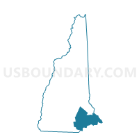
TOWN OF CANDIA Voting District, Rockingham County, New Hampshire
About
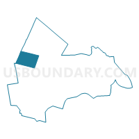
Outline

Summary
| Unique Area Identifier | 616438 |
| Name | TOWN OF CANDIA Voting District |
| County | Rockingham County |
| State | New Hampshire |
| Area (square miles) | 30.57 |
| Land Area (square miles) | 30.33 |
| Water Area (square miles) | 0.24 |
| % of Land Area | 99.21 |
| % of Water Area | 0.79 |
| Latitude of the Internal Point | 43.06144630 |
| Longtitude of the Internal Point | -71.31999690 |
Maps
Graphs
Select a template below for downloading or customizing gragh for TOWN OF CANDIA Voting District, Rockingham County, New Hampshire


Neighbors
Neighoring Voting District (by Name) Neighboring Voting District on the Map
- TOWN OF ALLENSTOWN Voting District, Merrimack County, NH
- TOWN OF AUBURN Voting District, Rockingham County, NH
- TOWN OF CHESTER Voting District, Rockingham County, NH
- TOWN OF DEERFIELD Voting District, Rockingham County, NH
- TOWN OF HOOKSETT Voting District, Merrimack County, NH
- TOWN OF RAYMOND Voting District, Rockingham County, NH
Top 10 Neighboring County Subdivision (by Population) Neighboring County Subdivision on the Map
- Hooksett town, Merrimack County, NH (13,451)
- Raymond town, Rockingham County, NH (10,138)
- Auburn town, Rockingham County, NH (4,953)
- Chester town, Rockingham County, NH (4,768)
- Allenstown town, Merrimack County, NH (4,322)
- Deerfield town, Rockingham County, NH (4,280)
- Candia town, Rockingham County, NH (3,909)
Top 10 Neighboring Elementary School District (by Population) Neighboring Elementary School District on the Map
- Hooksett School District, NH (13,451)
- Auburn School District, NH (4,953)
- Chester School District, NH (4,768)
- Allenstown School District, NH (4,322)
- Deerfield School District, NH (4,280)
- Candia School District, NH (3,909)
Top 10 Neighboring Unified School District (by Population) Neighboring Unified School District on the Map
Top 10 Neighboring State Legislative District Lower Chamber (by Population) Neighboring State Legislative District Lower Chamber on the Map
- State House District 3, Rockingham County, NH (29,082)
- State House District 1, Rockingham County, NH (17,215)
- State House District 7, Rockingham County, NH (15,141)
- State House District 9, Merrimack County, NH (13,451)
- State House District 8, Merrimack County, NH (12,994)
- State House District 2, Rockingham County, NH (10,138)
Top 10 Neighboring State Legislative District Upper Chamber (by Population) Neighboring State Legislative District Upper Chamber on the Map
- State Senate District 17, NH (58,086)
- State Senate District 16, NH (55,772)
- State Senate District 14, NH (53,549)
Top 10 Neighboring 111th Congressional District (by Population) Neighboring 111th Congressional District on the Map
Top 10 Neighboring Census Tract (by Population) Neighboring Census Tract on the Map
- Census Tract 550.01, Rockingham County, NH (5,944)
- Census Tract 442, Merrimack County, NH (5,646)
- Census Tract 40, Rockingham County, NH (4,953)
- Census Tract 510, Rockingham County, NH (4,768)
- Census Tract 31, Merrimack County, NH (4,322)
- Census Tract 560, Rockingham County, NH (4,280)
- Census Tract 500, Rockingham County, NH (3,909)
Top 10 Neighboring 5-Digit ZIP Code Tabulation Area (by Population) Neighboring 5-Digit ZIP Code Tabulation Area on the Map
- 03106, NH (13,374)
- 03275, NH (11,437)
- 03077, NH (10,155)
- 03032, NH (4,953)
- 03036, NH (4,782)
- 03037, NH (4,219)
- 03034, NH (3,970)